

I first wrote this article in July 2014 for a forum I am on. I have published it here for those not on the forum.
I’ve been trying to work out how to write this for a week now, ever since I started the decent. How do I word it? Where do I start?
I suppose the easiest start point is about 7 years ago. I was on holiday in Hay-on-Wye with some friends. It was the Easter weekend, and I thought it would be a great idea to climb Pen-y-Fan. So we set off in a couple of cars, and parked on the northern side of the Beacons, at SO025249. By the time we had done only a couple of Km we stopped for lunch. With discretion the better part of valour, I turned round and headed back to the car. I had been defeated, not by the mountain, but by my own body. Injury turned me back.
Fast forward to 2014, and the same group of friends has decided to have our summer holiday in the village of Talybont-on-Usk. Looking at the map I notice that Pen-y-Fan is very close. The injury that turned me back last time has had 3 rounds of physio treatment. I’m feeling fit.
So I propose to the group that I would like to do Pen-y-Fan. Not expecting anyone else to be mad enough to join me, I start looking at the bus options for Talybont to the Storey Arms to start the hike. But, before I’ve got the buses entirely worked out my inbox is alive. Not only do some of them want to join me, but they have proposed a route alteration that cuts 10k of the hike (more on that later). I’m not doing it alone. It’s going to be 13 of us, plus two hounds.
When I proposed the hike to the group I put forth two routes, which I names short, and long. The short route goes up one side of the mountain from the Storey Arms, over Corn Du, and to the top of Pen-y-Fan, then back via a similar route to the car. The long route is the same as far as the peak of Pen-y-Fan, but then descends the other side, and on towards Cribyn, Fan-y-Big, along the Breacon Beacons way to the end of Talybont Reservoir, and then along the taff trail back to Talybont. About 20k all up.
The altered proposal that was put forth was to park a car at the end of Talybont Reservoir at the car park at Torpantau. Then we all go by car to the Storey Arms, then when we’ve completed the hike, we shuttle the drivers back and forth until eventually everyone is back in Talybont and we can go to the pub. Hurrah, the route is now just under 11km. Christened Pen-y-Fan-not-so-long.
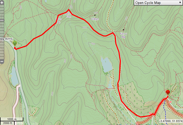
Pen-y-fan-not-so-long
What I thought would be a solo hike up and over Pen-y-Fan, is now an international group expedition across upto 4 peaks of the Breacon Beacons. Just a small amount of mission creep there. The group of 13 was made up of 2 Belgians, 2 Germans, an Austrian, a Brazilian, 6 Brits, and 2 dogs.
Plans made, we all headed to bed pretty early so that we could get up early to try and do as much of the walk as we could before it got to hot. I noticed the village shop and cafe opened at 0700, so I decided I would get up and have a decent fry up to get me through the day.
0630 rolls round and I crawl out of my tent into a comfortably warm campsite. A few of the others have started to surface and we head to the cafe. The sign on the shop door said they open at 0700, and the shop does. Alas the cafe doesn’t open until 0900. By which we hoped to be on the move. Plan B, raided the shop for some supplies (Mars bar is an acceptable breakfast on a mountain hike right?).
At the meeting point I sat down and wrote an email to a friend in Kent. The email said how many of us there would be, what route we were taking, and when we were due back, with explicit instructions that if we didn’t contact by 1 hour after the due back time, to call Mountain Rescue. Email done, group gathered we pile into cars for the short drive to the Storey Arms.
It took us 4 cars to get everyone to the Storey Arms car park (the southern most of the two), one of which would return to Talybont after he had dropped us off.
We stood at the bottom of the mountain passing round the sun cream, alternating our gaze between the sun that was scorching us from above, and the path we intended to take. It started to sink in with some in the group as to what we were about to do.
Sun cream done, we thanked the guy who had brought the 4th car, confirmed the time we hoped they would meet us at the end of the route and headed for the track.
Within 100 yards of starting the group had split naturally. With me in the tail end group was 2 Belgians, 1 German, myself, a second brit, and a dog. We wouldn’t see the rest for quite a while.
I had a rough idea based on last time what was ahead of me, so settled down into a mountain pace, one foot just in front of the other, head up, poles out, plod plod plod.
As we walked stopping occasionally to enjoy the various people wandered past us at varying paces, each faster than what we as a group were doing. At 700m or so we stopped for a water break. Our intent to miss the hottest part of the day hadn’t worked, the sun was beating down on us, there was no shade, and no breeze. Drink lots of water, sweat lots, keep on going. It would become a running joke over the course of the day “Drink more water” we all said to each other, and then to everyone who wandered past.
After we had been climbing for an hour or so, from the top of the mountain appeared a soldier, in full combat kit with a slingless rifle in his hands. Sweat streaming everywhere, he looked like he had been running for a while. Were we climbing Pen-y-Fan when the Fan dance was in progress? 100 yards beyond the first soldier was another, then another. This one looked dead, but still running down the mountain. He didn’t respond when we said morning, unlike the others. This would become another theme of the day, hot sweaty soldiers running past us with giant bergens on their backs topped with an Orange air marker panel.
One foot just in front of the other, drink more water, repeat. We plodded up the mountain.
Just short of the first peak of the day we pulled out the map and took a look. Damn. What we had been aiming for isn’t Pen-y-Fan, it’s Corn Du. We had a brief analysis and discussion. Did we want to climb this one too? There was a path round the summit we could miss it out and just do Pen-y-Fan. As a group we all went over Corn Du.
The final ascent to Corn-Du is the steepest of the whole walk, in places it’s a case of stepping from one large boulder to the next, a bit like over sized steps. But after a few minutes, we all wandered to the cairn on the top of the mountain.
The view was spectacular.
After a photo and water break (drink one, take the other…). We looked at the path down to the saddle then up to Pen-y-Fan. Oh that looks better we thought. In hind sight, if I was going to do the loop back to the Storey Arms, I would go first to Pen-y-Fan, then back up to Corn du, then down again. But we were there, and down we go.
We could see our aim we could see the target. It brought forth a burst of energy, and we all strode down the saddle and up the other side. As the incline steepened, I switch back to the mountain pace, foot just infront of the other, plod, plod, plod. I couldn’t beleive it. On my second attempt I was going to do it, I was going to reach the top. I felt great.
Too great.
50m from the summit I could see the cairn. I lifted the poles from the ground, scinched my pack straps, and ran for it. A sprint finish, I was going to make it!
I ran the 50m over the rocky ground, jumping from stone to stone, passing my friends as I did, and arrived at the cairn. Gulping down great lungfuls of breath I climbed the cairn, dropped my poles, and crumpled in a heap. I’d DONE IT! It felt great. Seven years after starting, I had finally made it to the top of Pen-y-Fan.
Once I had my breath back, we decided that we would move down a bit off the top to have lunch. Away from the flying insects that seemed to cover the tops, and only the tops of the mountains.
On the way to the path down, there was a small green tent, with a couple of squaddies lounging around it.
“Hi, are you allowed to talk to civilians?”
“Sure.”
We exchanged some pleasantries.
“What are they up to? is this the fan dance?”
“No, it’s a long drag”
“Ouch, how far are they going?”
“22km today”
“Just getting up here has almost killed me, I have a whole new found respect
for you guys. Have a good day”
“And you”
I wandered back to the path, and joined my friends 50m or so below the summit.
The view from Lunch
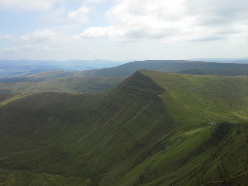
We had lunch and chatted, admiring the view down the valley towards Cribyn and Fan-y-Big. Punctuated into the distance by small orange air marker panels on the tops of bergans.
View down the valley
Lunch over (another healthy marsbar…), we debated our next move. From where we sat we could see Cribyn ahead of us, and we could see the path round it. It was a unanimous decision that we miss out on the next top, and take the low road.
We plodded on once more. Down hill my stride lengthened, as much as the terrain allowed. The stones that the national trust has used to shore up the path are uncomfortable under foot, like walking on paving slabs stood end on end. My knees didn’t like the decent, making me very appreciative of my walking poles.
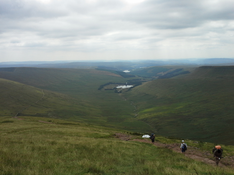
We stopped at the southern side of Cribyn for another water break, punctuated yet again by exhausted soldiers trekking past. They had obviously started to reach their turn around point, as now we had them going in both directions. We drank water, and admirred the view. Noting as we did that one of our party, the owner of the dog, wasn’t with us. We hoped that they were just round the corner chasing down where ever the dog had got to. Rested and watered, we plodded on.
At the saddle between Cribyn and Fan-y-Big, we found our missing member, sat waiting for us. He had realised we weren’t behind us, so waited at a convenient junction for us.
As we arrived here we recognised the tinkle of a bell, and a familiar voice. Looking up the path to the top of Cribyn, we saw the trail blazer group that had zoomed ahead of us on the first ascent. We greeted each other with congratulations at having got this far. Chatted about what we had achieved, and posed for a group photo.
Following this we had a bit of a discussion, who wanted to try the planned route up Fan-y-Big, and who found the low road that we could see round the valley back to the car park. In the end one of the tail end group swapped into the trainblazer party, and we went our separate ways. I texted the friend in Kent with the details of our route deviation.
Now we were on the flat, we could lengthen the stride once more and eat up some miles. We pressed on along the taff trail, passed by some very enthusiastic mountain bikers.
As we reached the corner of the forest, we stopped for a final water break, and to admire the view up the valley. By now the weather had clouded over, giving a rather moody sky over the mountains.
We walked on, crossing down and then up the other side of a rocky gulley and along the forest road. We had a spring in our step and were looking forward to the car ride back to Talybont, and the pub.
As we exited the woods and entered on to the road, we looked up at the incline of the flat road. Looked at the GPS telling us it was still 1.2km to the car park. And swore. All of us doing so in English…
We decided to stop for a final final water break before taking on the final kilometer.
From here to the car park it ceased to be a walk, it ceased to be a plod, it had become a slog. There was no breeze, there was no sun, just a muggy humid discomfort of stillness. We didn’t talk to each other, just cursing the aches and pains of the various parts of the body we had picked up over the hike.
We slogged on.
At the top of the road we passed a collection of green vehicles with their gathering of orange air marker panelled bergan carrying soldiers. They looked exhausted. I stopped and asked the driver of the green ambulance for directions to the car park. The cheery soldier gave my directions the final 200 yards.
We slogged on.
Finally we turned the corner and stumbled up the 50m of track to the stream by the entrance of the car park. Here we met the Austrian and the Brazilian that were the scouts for the trailblazer party. They said that the rest of them were not far behind. We collapsed round the stream, some removing their shoes to cool their feet in the stream.
I filled the pouch for my sawyer from the stream (upstream of the others), and drank the best tasting coldest water I’ve ever had.
With all members of both groups accounted for. We sent off a car load of people to find more cars, and get us down, while being very British, one of the Germans in our party put the kettle on and made us all tea…
An hour later, and involving 6 cars in total. We all made it back to Talybont.
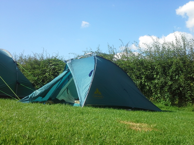
Back at my tent.
I got a lift back to my tent, where I collapsed in the shade of the car. I’d done it. On my second attempt, I’d done it. I had got to the top of Pen-y-Fan. The euphoria at having achieved this made the pain in my legs
worthwhile.
I lay there, staring up at the Ash tree above me, pondering what I had done.
You see many people talk of how they “conquered Everest” “Took on the mountain and won”. I thought about what I had done. Had I conquered Pen-y-Fan? No not really, the mountain is still there. Did I take on and defeat the mountain? No not really, the mountain just sat there and did what mountains do. So what did I do? Even now, a week on, I can’t think of a way of wording it. I’ve consulted various people, picked the brains of a Librarian, a Poet, and a Dane. I’ve analysed the thoughts, but I can’t work out a suitable way of phrasing it. Pen-y-Fan is still there, unchanged. Standing sentinel to time.
So if the mountain is still the same, am I? That’s a good question. Am I the same Julia that set off from the Storey Arms one Tuesday in July? I know I’m not the same one that set off one Easter Saturday long ago. My feet are sore. My walking poles worn. The memories of achievement living in my mind. I embraced the mountain, and let it teach me just a little bit more about the world.
If you are interested in climbing Pen-y-Fan, you may find the routes I created for my trip useful. You can find them on viewranger.
- The high road – The route the Trailblazers took.
- The low road – The route myself and the tail end group took
- Loop back to the Storey Arms – This is my original short route proposal. I would suggest missing out Corn Du on the way to Pen-y-Fan, and then climbing it on the way back instead.
- Long route from Storey Arms to Talybont – This is the original long route proposal.